User guide
Data processing levels
The Hub provides free and open access to Sentinel-1, -2, -3 and -5P products processed to different levels of specifications, as summarised in the table below.
| Data Processing Level | Sentinel-1 | Sentinel-2 | Sentinel-3 | Sentinel-5P | |||
|---|---|---|---|---|---|---|---|
| OLCI | SLSTR | SYNERGY | SRAL | ||||
| Level-2 | Ocean data | Bottom of Atmosphere (BOA) Reflectance data |
| - | - |
| Atmospheric data |
| Level-1 | Single Look Complex & Ground Range Detected data | Top Of Atmosphere (TOA) Reflectance data | TOA Radiance data | - | - | Preprocessed Radar altimeter Bursts, Echoes and Stacks | - |
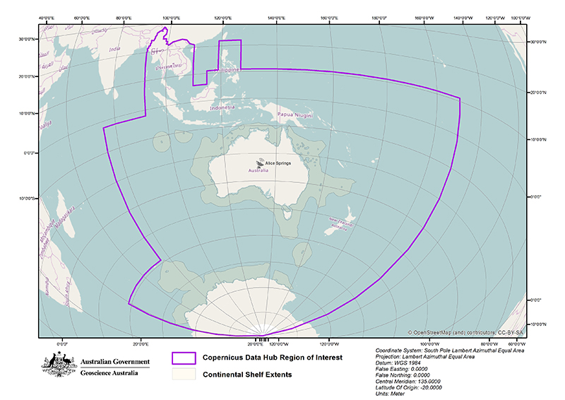
Region of interest (ROI)
The Sentinel products cover a ROI over Australasia, South-East Asia, the South Pacific, the Indian Ocean and the Australian Antarctic Territory, as depicted in the map below.
Product capture and management
The Hub’s product capture and management regimes are given in the table below.
| Mission - status / *acquisition plans | Product | Region of capture and management regime by the Hub |
|---|---|---|
| Sentinel-1A - operational [3 July 2014 - present] Sentinel-1B - decommissioned [25 July 2016 – 3 August 2022] *The Sentinel-1 acquisition segments with the related mode and polarisation are defined on a 12-day cycle. The high-level operations plan can be found in the observation scenarios. The Sentinel-1 ground segment production baseline is described in the production scenario. | GRD – Full Resolution GRD – High resolution GRD – Medium Resolution SLC OCN | Sync products over ROI |
| Sentinel-2A - operational [23 September 2015 - present] Sentinel-2B - operational [7 June 2017 - present] *The Sentinel-2 acquisition plans are routinely provided based on weekly planning. | Level-1C TOA Level-2A BOA | Sync products over ROI |
| Sentinel-3A - operational [16 July 2016 - present] Sentinel- 3B - operational [25 July 2018 - present] The Sentinel-3 instruments autonomously perform systematic and continuous sensing following the Sentinel-3 observation scenario. |
OLCI Level-1B TOA OLCI Level-2 – Marine and Land SRAL Level-1+ Level-2 | Sync globally, remove any ‘time critical’ products that have been superseded, then maintain ROI data after 60 days post 1 July 2019. |
| Sentinel-5P - operational [13 January 2018 - present] | TROPOMI Ozone (O3) total column Nitrogen Dioxide (NO2), total and tropospheric columns Sulfur Dioxide (SO2) total column Carbon Monoxide (CO) total column Methane (CH4) total column Formaldehyde (HCHO) total column Cloud fraction, albedo, top pressure UV Aerosol Index Aerosol Layer Height (mid-level pressure) | Sync global products |
We aim to make 90 percent of these products available in Australia within 24 hours of it appearing in the European hubs. Successful data replication, completeness and consistency with the European hubs are checked routinely and cleaned monthly.
For more information about latency and completeness of the Hub data, see the reporting dashboard.
Adding new products
As new Sentinel missions are launched, new products are added to the Hub based on the needs of its users, which currently includes:
- government partners that finance its operation
- industry
- the research sector
- academia
- non-government sectors across our region
For technical information about the Sentinel satellite missions, see Sentinel Online.
If you require any Sentinel products that fall within our ROI, but are not listed in the above tables, please contact CopernicusAustralasia@ga.gov.au
More information
For further details on Sentinel products, access and applications, see the Resources page.
If you experience any issues with products downloaded from the Hub, please report them to CopernicusAustralasia@ga.gov.au.